
You are viewing the expanded version of this Harbour,
for faster browsing
use the regular version here
Craster Harbour and Anchorage
Courtesy Flag
Flag, Red EnsignWaypoint
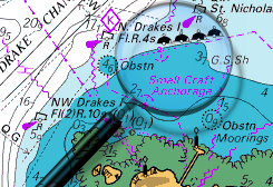
Approach from East, between the Carrs 55:28'.44N 001.35'.21 WCharts
Admiralty 156Rules & Regulations
UnknownHazards
Rocky Ledges, see ext. Harbour DriesTidal Data Times & Range
Approx Dover +0350This site is designed for slower, roaming broadband connections, like you would get at sea, so it needs JavaScript enabled to expand the text.
General Description
Craster could be useful stop if passage making North or South down this coast.
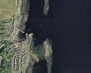
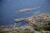
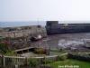
It consists of a small drying harbour with a slipway and adjacent village. Although the harbour could be used by boats prepared to take the ground the area is probably more useful as a passage anchorage.Two rocky outcrops, Big Carr just to the south of the harbour and the isolated island of Little Carr just to the north-east of the harbour entrance can provide some useful protection to the anchored mariner from swell, especially away from the top of the tide.
Obviously this is not a place to consider in onshore conditions. In more settled summer weather the anchorage could provide reasonable protection in winds from the North West through to the South anticlockwise. It should be noted that NE Coast sailors do not consider this port as anything other than a day sailing destination for a lunchtime stop.
There are small village facilities ashore including pubs, and the village speciality is smoked herring. Craster kippers are famous, but the herring arrive at the harbour by road now for the local smokehouses.
Local fishing consists of small boats potting for lobsters.
Approach
Craster harbour and anchorage lie about a mile to the South......
...... of the conspicuous ruins of Dunstanburgh Castle to the North.The rocky reefs of Great Carr and Little Carr with it's stone beacon protect the harbour somewhat.
Great Carr to the South of the harbour is always uncovered and should be visible. Little Carr can be almost awash, but there is a stone beacon at the southern end which should be visible.
Between Great Carr to the South and the southern end of Little Carr there is a clear and steep sided gap of over two cables (400m). Also between Little Carr and the shore there is navigable channel with at least 3 m in it. If poking your nose in this channel be aware of the rocky ledge just to the west of Little Carr, shown on the sketch and in the photo gallery.
Probably the safest approach is the former, the entrance to the little harbour will be clearly seen.
There is no Harbour Master here as such but enquiries can be made to the Kipper Shed 01665 576223 .
Berthing, Mooring & Anchoring
For anchoring probably the best spot is between the Carrs and off the harbour entrance in over 3 m at low water.
It may be a good idea to buoy the anchor in case it gets snagged on a rock. Dinghy landings can be made at the slipway.
If you're prepared to take the ground it is possible to enter the harbour about three hours either side of high water for moderate draft craft, and moor against the East Pier. Local small fishing boats tend to use the North Pier, where there is slightly more water and better protection.
The waters shallows deeper into the harbour and the South West area of it is foul. The bottom is fairly level and clean consisting of sand and pebbles (see photo gallery). Keelboats may need to rig a halyard from the masthead to make sure they lean inwards. The wall surfaces are not particularly topside friendly so good fenders and fenderboards will be needed.
Swell can find its way into the harbour.
Facilities
Nothing much here for the boat other than the slipway for dinghy landings, this needs to be kept clear at all times for the inshore lifeboat housed in the boatshed.
There is not even a fresh water tap!
One village general shop ( see photos), one pub and the smokehouse/resturant.
Good walking area.
History
Craster is a small fishing village on the Northumbrian coast of England. It has a small and attractive harbour and offers a view northwards along the rocky shore to the spectacular ruins of Dunstanburgh Castle. This is the nearest point of access to the castle and the approach must be made on foot as there is just a grassy path. The next village to the north is Embleton.
For many years, the village has had a herring-curing business: Craster kippers are well known in England. The local herrings are smoked in a traditional manner by the Robson family.
The remains of a tower on the end of the harbour are all that can be seen now of the much taller building which was part of the overhead equipment which used to convey the local stone from where it was quarried to boats in the harbour. A small distance inland lies Craster Tower, the home of the Craster family who owned the quarry and had the harbour improved for its benefit. A memorial on the harbour wall commemorates a member of the Craster family who died serving with the British army in Tibet in the 19th century,the development of the harbour was as a memorial to their son.
The walk along the coast to the south is almost as spectacular as that to the north and passes by Cullernose Point, an example of the basaltic cliffs which are a significant feature of the local landscape. It is within the Northumberland Coast Area of Outstanding Natural Beauty.
The text on this HISTORY page is covered by the following licence
http://en.wikipedia.org/wiki/Wikipedia:Text_of_the_GNU_Free_Documentation_License
Eating, Drinking & Entertainment
In the village, just the places already mentioned. It's unlikely the anchored skipper will wish to stray far anyway.
Links
|

Got a comment to make about Craster Harbour & Anchorage ? Have you found this coverage helpful ? HAVE YOUR SAY (your email address will always be kept private)
Your Ratings & Comments
There is currently a freshwater tap across the road, and this (with an extension hose) can feed another hose which runs under the road through the stream culvert.
The Jolly Fisherman pub, 50 m from the harbour serves excellent beer and meals, particularly fish based.
Offshore winds are common, and because of the location of the Carrs there is frequently dirty water at the entrance.